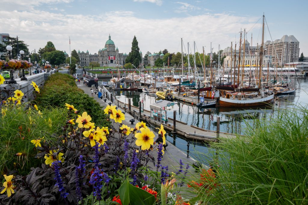
Follow this guide for a walking tour of Victoria Harbour East, and all the maritime connections along this beautiful route.
Read the following blog, download the printed version (to print on 11″ x 17″ paper), or stop by the Maritime Museum of BC to pick up a copy!
About This Walking Tour
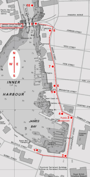
This self-guided walking tour focuses on maritime history along the east side of Victoria’s bustling working harbour, but there are many other things to see along the way.
The walk is an easy 1.2 km (3/4 mi) and should take around one hour to complete. There are several spots to sit with views over the harbour. A public washroom is available beneath the Victoria Information Centre [Stop 3].
This guide starts at the BC Steamship Terminal Building [Stop 1] heading eastward along Belleville Street toward the Empress Hotel, then northward along Government and Wharf streets to the north side of the Johnson Steet Bridge [Stop 10].
Image:
A portion of the nautical chart showing the stops along the east side of Victoria’s Inner Harbour.
Chart 3412, Victoria Harbour, Canadian Hydrographic Service, Fisheries and Oceans Canada
About Victoria’s Harbour
The Hudson’s Bay Company’s (HBC) Chief Factor James Douglas (1803-1877) selected this well protected harbour in 1842 for the company’s fort on southern Vancouver Island. The following year, a 100-metre square fort was constructed and soon afterwards became known as Fort Victoria, named for the Queen of England. Fort Victoria evolved into the City of Victoria by 1862. This area is within the traditional territory of the Lək̓ʷəŋən (pronounced Lah-kwa-ngun) peoples, who are known today as the Songhees and Xwsepsum (Esquimalt) Nations and whose historical relationships with the land and harbour continue.
Much of the harbour and adjacent lands are administered by the Greater Victoria Harbour Authority. Businesses operating in the harbour area include ferry and catamaran services, several sea plane companies, whale watching tours, fishing charters, kayak tours and rentals, marinas and restaurants. The harbour waters are also frequented by commercial ships and barges, and by recreational boaters and kayaks. Transport Canada’s “Port of Victoria Traffic Scheme” keeps all marine and seaplane traffic moving in a safe and orderly fashion.
This tour was researched and compiled in 2026 by MMBC staff and volunteer Doug VanDine.
Stop 1: BC Steamship Terminal Building
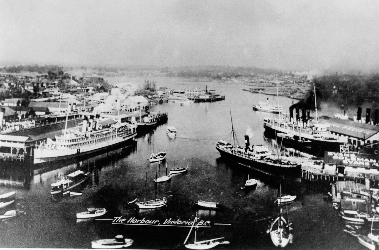
This Neo-classical building was designed by architects Francis Rattenbury (1867-1935) and Percy Leonard James (1878-1970) and constructed by the Canadian Pacific Railway (CPR) in 1924. Until 1960, it was the terminus of CPR’s coastal and trans-Pacific steamships including SS Princess Victoria and SS Princess Marguerite. In 2005, it was listed by the Canadian Register of Historic Places. The building was seismically upgraded in 2010 and is currently owned by the Province of British Columbia.
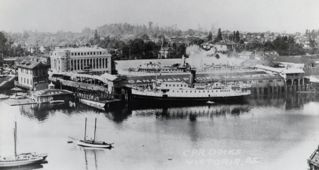
(MMBC Archives P1815.01)
It is hoped that the Maritime Museum of British Columbia, in association with the Songhees and Esquimalt Nations, will eventually move into a portion of the building to create a new cultural hub in Victoria’s harbour.
Between 1 and 2
As you walk east on Belleville Street, look over the harbour side of the sidewalk and you’ll see flower beds that spell “WELCOME TO VICTORIA”. During the summer, these are planted with a colourful array of flowers to represent Victoria’s nickname, “the Garden City”. The walkway immediately below the beds is a portion of the “David Foster Harbour Pathway”, named to honour the Victoria-born musician who has won numerous Grammy and Juno awards.
The impressive British Columbia Parliament Buildings that house BC’s Legislative Assembly are located across Belleville Street. The buildings and grounds are worth a side trip.
Stop 2: Belleville and Governments Streets Intersection
At this intersection, the Royal British Columbia Museum is to your right, and the Empress Hotel is to your left. Like the Steamship Terminal and the Parliament Buildings, the hotel, constructed between 1904 and 1908, was designed by Francis Rattenbury. It was designated a National Historic Site in 1981. The museum and hotel are both worth a visit.
The granite stone causeway and this portion of Government Street, which extends northward to [Stop 3], was constructed between 1901 and 1903. It replaced a wooden bridge constructed across the tidal flats of James Bay in 1859 to connect Fort Victoria, to the north, with the then recently constructed wooden government buildings to the south. The stone causeway allowed the tidal flats to be filled in and the Empress Hotel to be built.
In 1974, a Lower Causeway walkway was added, creating a lively space for street performers and craft sellers and providing better access to the Causeway Marine floats. A First Nations exhibit consisting of five panels explaining their original use of the area was erected in 2026.
You will also see many small brass plaques attached to top of the granite stone causeway wall. These plaques, known as the “Parade of Ships”, commemorate famous vessels in the history of Victoria and pay tribute to pioneers they brought. Two plaques are highlighted below. The first is located near the south end of the causeway; the second is located at the middle staircase.
- The first commemorates John Guzzwell’s solo circumnavigation in Trekka. Guzzwell constructed Trekka (6.3 m (20.5 ft) in Victoria. It is now a prized possession of the Maritime Museum of British Columbia.
- The second honours Captain J.C. Voss’s Pacific voyage in Tillikum. Voss converted what was a wooden dugout canoe into an ocean sailing vessel. Tilikum is another prized possession of the Maritime Museum of British Columbia.
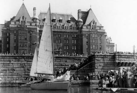
Over the Labour Day weekend each year, the Maritime Museum of British Columbia hosts its Classic Boat Festival on the Causeway Marine floats. Typically, more than 80 classic boats from the Pacific Northwest United States and Canada attend this festival.
Stop 3: Victoria Information Centre
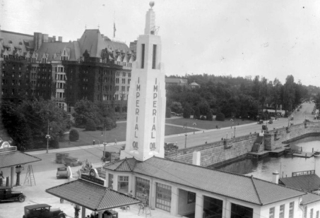
The centre is housed in the upper, street-level floor of the former three-story Imperial Oil service station and marine fueling dock.
Constructed in 1931, this Art Deco building was designed by the architect firm Townley and Matheson . A 10 million candle-power beacon was installed at the top of the 24 m tower as a navigational aid in anticipation of Victoria’s harbour becoming an important float plane base. The beacon is no longer used. Imperial Oil closed the service station in the late 1970s, and the building has served as an information centre since the early 1980s. It was placed on The Canadian Register of Historic Places in 1986. The City of Victoria purchased the building in 2015 and today a restaurant, a whale watching company, a retail tourist outlet and public washrooms are located in the lower levels.
Stop 4: Navy Plaza, Ship Point, Floating Spa and Water Ballet
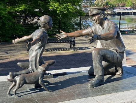
This plaza was dedicated in 2010 to commemorate the Royal Canadian Navy’s 100th anniversary and the sailors who served Canada. “The Homecoming” statue by artist Nathan Scott depicts a sailor reuniting with his family after returning from sea. The granite and marble base beneath the statue displays crests of each ship in the Canadian Navy’s Pacific Fleet. The plaza also includes storyboards detailing 100 years of Canadian naval history, inscribed bricks in memory of service members, and plaques for its five seas of operation.
A second statue unveiled in 2011, also by Nathan Scott, depicts a veteran sailor sitting on a bench overlooking “The Homecoming”. It honours Captain John Mason, who served on the HMCS Naden during WWII. He is holding a copy of the Victoria Daily Colonist declaring Victory in Europe, May 8, 1945.
The wharf below Navy Plaza was named Ship Point in the 1850s. By the early 1900s, this point became a hub for maritime commerce. In 1910, the Grand Trunk Pacific Railway (now part of CN Rail) constructed the large wharf you see to your left. Today, the Ship Point Marina accommodates large vessels (20 m and over) and luxury yachts. The south side of the wharf is a great place for watching the water ballet performed by five harbour ferries (a.k.a. pickle boats). The 15-minute ballet is performed most Saturdays, Sundays and holidays at 10:30 am, mid-May through early September.
Stop 5: Old Customs House
As you walk towards [Stop 5], look over the lower parking lot and you will see a large area where summer markets and concerts are held. The site is also home to a large float plane base and restaurant. Since 2023, a dark-coloured floating spa has been permanently moored to your left. It is a re-purposed 1943 US Navy barge and features saunas, hot tubs, and cold pools. The Ship Point venue is currently undergoing re-design to both celebrate its history and maintain its functionality.
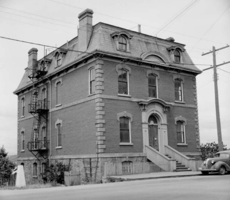
The Old Customs House, also known as the Malahat Building, when completed in 1875, was the first federal building constructed in the province. It was designed in the Second Empire style with a rooftop viewing deck so that customs officers could monitor maritime traffic.
The customs house was located in Victoria because, at that time, Victoria was BC’s busiest port and the centre of commerce in the province. It served as the customs house until 1899, then a post office and a police station. It was designated a National Historic Site of Canada in 1987, and is now a mixed-use building.
Stop 6: “Green” for 75th Anniversary of the Navy and mooring rings
This relatively small park is referred to as the “Green”. It was dedicated in 1985 to mark the 75th anniversary of the Royal Canadian Navy, and was rededicated in 1998 to remember the 75th Royal Canadian Naval Reserve’s anniversary. The Admiralty Pattern anchor, and the Japanese cherry tree behind the anchor, were donated by CFB Esquimalt Naval and Military Museum to symbolize the strong bond between the navy, based in neighbouring Esquimalt, and the City of Victoria.
The Green is also home to a Lək̓ʷəŋən spindle. There are seven spindles located in the Victoria area, all created by Songees artist Butch Dick. The spindles depict whorls, a traditional tool for spinning wool, and are in places of cultural and historical significance to the Lək̓ʷəŋən peoples. This spindle marks the southwest corner of the HBC’s Fort Victoria. The fort was initially named Fort Camosun (ca-MAH-sing), from the native word representing “the coming together of different waters [a metaphor for different people] to transform”. The fort, constructed with the help of the Lək̓ʷəŋən peoples, resulted in a drastic change to their traditional way of life.
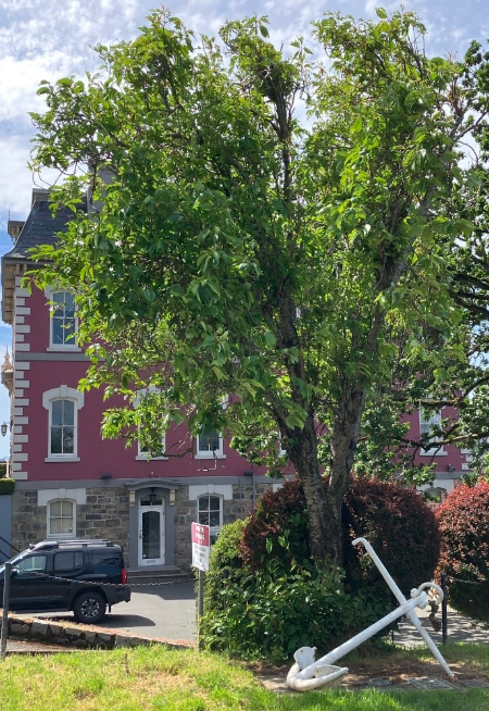
Down the slope, to the right of the Government of Canada plaque, you can see an iron mooring ring drilled and cemented into the bedrock. It and several others are the only surviving remnants of Fort Victoria, and indicate the location of the original shoreline where company ships would moor to unload trading goods and passengers.
Stop 7: Bronze Hands and Binoculars, HBC Wharves, Fort Victoria and early Victoria businesses
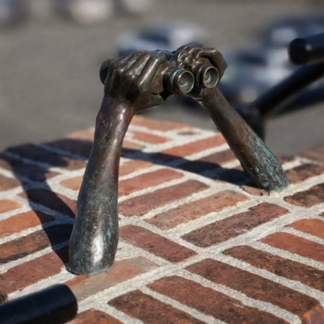
Further northward along Wharf Street, you will find a chest-height bronze sculpture of hands holding binoculars looking out towards the harbour. This is one of 12 “Hands of Time” sculptures by Crystal Przybille, located around Victoria. Erected in 2012, they celebrated the city’s 150th anniversary. A downloadable City of Victoria brochure shows the locations and describes of all 12 “Hands of Time” sculptures. They make for a wonderful scavenger hunt.
In the 1850s, what is now the Wharf Street floats and a parking lot were several bustling wharves and warehouses constructed by the HBC and others merchants. Besides the current Wharf Street floats this area is home to a whale-watching company and a float plane base.
Looking away from the harbour, you can see roughly where Fort Victoria was located from 1843-1864. The row of buildings along this block represents some of the oldest buildings and early businesses in the city. Construction occurred between 1861 and 1871. At the north end of this block is the entrance to Bastion Square, another historical area of Victoria worth a side trip.
Stop 8: Wyland’s “Whaling Wall”
As you walk further northward between [Stop 7] and [Stop 8] you will pass several historical stone and brick buildings on the waterside of Wharf Street. Except for the Victoria Regent Hotel, built in the 1980s, these buildings were constructed during the 1860s to 1880s, and were all associated with maritime commerce.
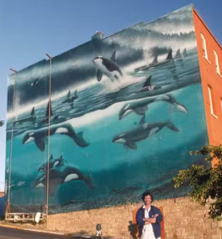
[Stop 8] is located by Reeson Park. Looking southward is a wall-sized and life-sized mural of the A5 pod of orcas (killer whales). Dedicated in 1987, it was the 13th of 100 “whaling walls” designed and painted globally by Robert Wyland. The A5 pod is a group of northern resident, fish-eating whales found in coastal waters from mid-Vancouver Island north towards Haida Gwaii.
There were about 15 whales in this pod in 2024. The artist has recently expressed a desire to restore this cracked and faded mural.
Looking northward, there are two small derelict brick and stone buildings. They are two of the oldest commercial buildings in Victoria, built between 1860 and 1864. Current development plans propose to retain portions of these historically significant buildings.
Stop 9: Johnson Street Bridge
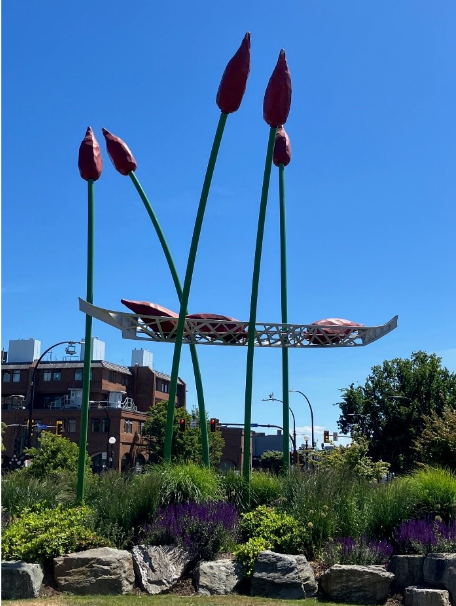
Just past the two derelict buildings, DON’T cross the street but turn left to go down a slightly inclined paved path to the south side of the Johnson Street Bridge [Stop 9]. Before you take the path, look northward (to the right) to see a giant aluminum canoe sculpture held in the air by five tall green reeds, each topped with a bright red seed pod. The canoe is a symbol of movement, trade and connection of people and goods in the harbour area. The sculpture was created by artist Illarion Gallant, and unveiled in 2008.
Now, walk a short distance down the path onto the pedestrian walkway of the Johnson Street Bridge. The current bridge was completed in 2018. It is referred to as the “Blue Bridge”, because the previous bridge was painted blue and the current bridge is awash in blue lights at night. This bridge is the fourth structure at this location to connect downtown Victoria and Vic West (on the west). Earlier bridges existed from 1854-1862, 1888-1924 and 1924-2018.
Like the previous bridge, the current bridge is a bascule (lift) bridge, the workings of which can be seen from the pedestrian walkway. If you are lucky, you can see the bridge rise to allow marine traffic to pass.
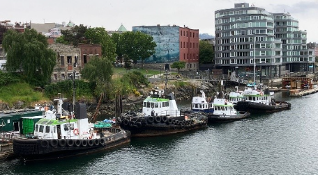
To the south are the Johnson Street floats, home to a fleet of tugboats used to guide cruise ships into their berths at the entrance to Victoria Harbour and to pull barges in and out of Victoria’s working harbour.
Stop 10: SALTS and Harbour Ferries
If you look northwards under the Johnson Street Bridge, or walk under the bridge to get a better view, you may see two large wooden schooners, Pacific Swift (length overall, 24.6 m (81 ft); beam 6 m (20.5 ft)) and Pacific Grace (length overall 35 m (115 ft); beam 6.7 m (22 ft)). They are the Sail and Life Training Society’s (SALTS’) two sail training ships.
SALTS, a registered charity founded in 1974, offers sailing voyages for youth ages 13–23, with a few programs for other age groups. Its motto is “training young people, by the sea, for life.” Each year, about 1,700 trainees from all walks of life experience mentorship aboard four- and five-day Gulf Islands trips and longer voyages along the BC coast. The schooners have also sailed across the Pacific Ocean several times.
While on board, youth learn to sail while building confidence, connection with nature, and community away from online distractions. Financial aid helps as many youth as possible set sail.
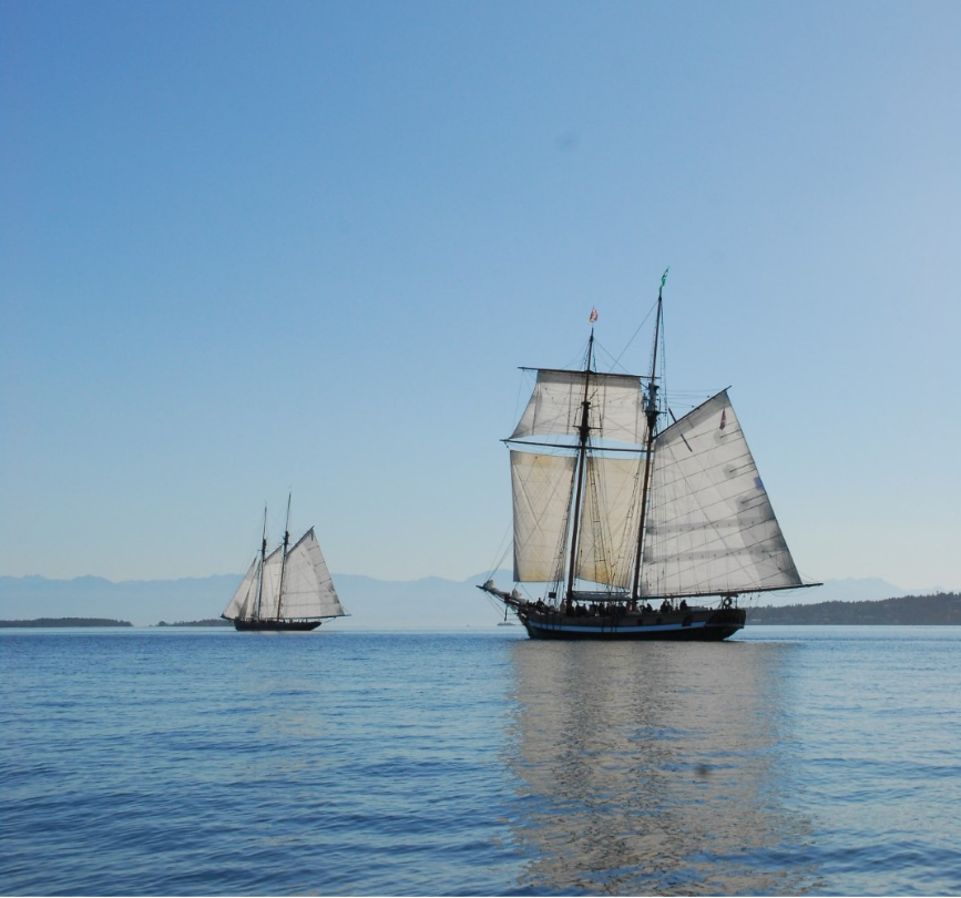
In 2017, the Lieutenant General of British Columbia, Judith Guichon, on behalf of the Maritime Museum of BC, presented SALTS with the “S.S. Beaver Medal for Maritime Excellence”.
The docks closer to the bridge are home of the Victoria Harbour Ferries. This fleet of ferries (often referred to as pickle boats because of their distinctive shape), has been in operation for over 30 years and offers scheduled water taxi trips from 14 designated pick-up stops within the Victoria Harbour, sightseeing tours and a unique water ballet.